The above app was created in response to a company that is looking to locate a new factory in the state of Alabama. The primary considerations for the location of the new factory were its distance to railroads(transportation) and rivers(resource). Therefore, perhaps the most important functionality of this map is a geoprocessing widget which looks like a toolbox. When the user clicks this button, a screen will appear that allow the user to input the desired distance of the factory to railroads and rivers visible on the map, dropping a pin of where they are thinking of locating, and setting the total distance area they would like to be included in the results comparable to the dropped pin. Once they click execute, the app will highlight a distance area that fits within the search parameters they entered and help them pick a future location for the factory. The highlighted area can also be measured so that they can determine how much space is available. Finally, the app can be shared with others so that they can too can complete these same tasks. All of these functionalities can help streamline the search for selecting a site for their new factory!
Next, we will take a look at the model builder that had to be built in order to create the sequence of events that allows the user to complete the search functionalities described above. The model builder was created in ArcMap and be viewed below along with a description that explains the image.
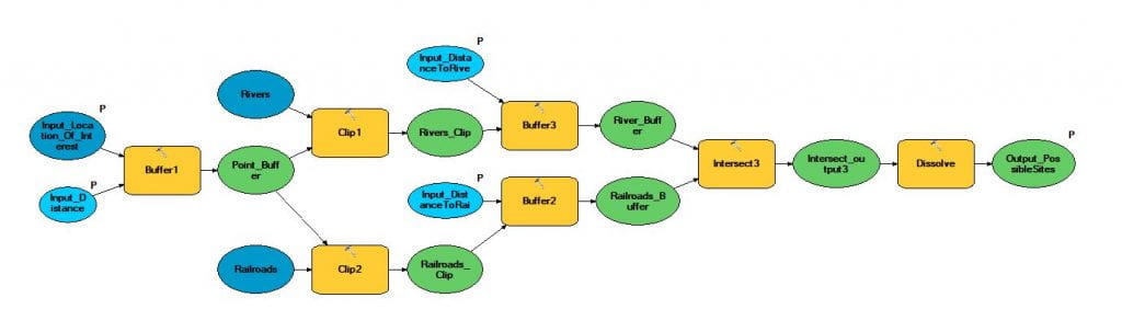
The logical flow of this model builder begins on the left-hand side and moves to the right until it reaches the final output which is possible sites. The first inputs will allow the user to click on a point and then create a search query where the user can enter a distance around this location that will create a buffer. These operations will then clip the areas of the rivers and railroad to the same buffer area, i.e. only railroad and river locations inside the buffer will be included in future steps. The next steps will allow the user to input a distance for the river and railroad clips that will again create a buffer. These two buffers lead to the intersect step so that only common ground between the two clips will be included in the next steps. The dissolve step merges the different polygons into a single polygon if and/or where they overlap. The end result will show a polygon that is within the original specified distance around the location the user clicked and within a specified distance of both the railroad and river clips to show the user potential sites that fit all their desired parameters.
